La Crónica
Old streets and lost names of San José de Gracia
Calle Real is Hidalgo now, the name callejón del Hueso is forgotten, and a small brick monument marks a founder's house that disappeared. This is the old town as its chronicler walked it, street by street.
Where the town ended before 1955
Before 1955, San José de Gracia ended in stone fences, corrals and pastures not far from the plaza. When Taurino Arámbula Vázquez corrected his chronicle in 1993, he walked his readers to the edge of the town he had known some 37 years earlier. [per Rincón Alteño, pp. 15-17]
The street that climbs toward the hill past the Delegación de Hacienda stopped at a stone fence. The streets toward the brickworks ended at the water tanks, and there was no way out to Tepatitlán through Calabazas, only corrals. To the east, a stone fence closed the street at the house of the late Don Pascual Barba, with one gate into an old house that stored the tithe corn. [per Rincón Alteño, p. 16]
Every street of the barrio del Colorín that opened to the west was blocked by a stone fence. Calle de la Rana reached only to the house of Don Pedro Gutiérrez, and beyond it were corrals where the traveling circus set up. Calle Real ended a short way east of the plaza at a fence around a field of maize. The plazuela, land the elders donated for a chapel to the Holy Family, was bare dirt and later a volleyball court; the DIF building stands there now. [per Rincón Alteño, pp. 16-17]
Names you will not find on the map
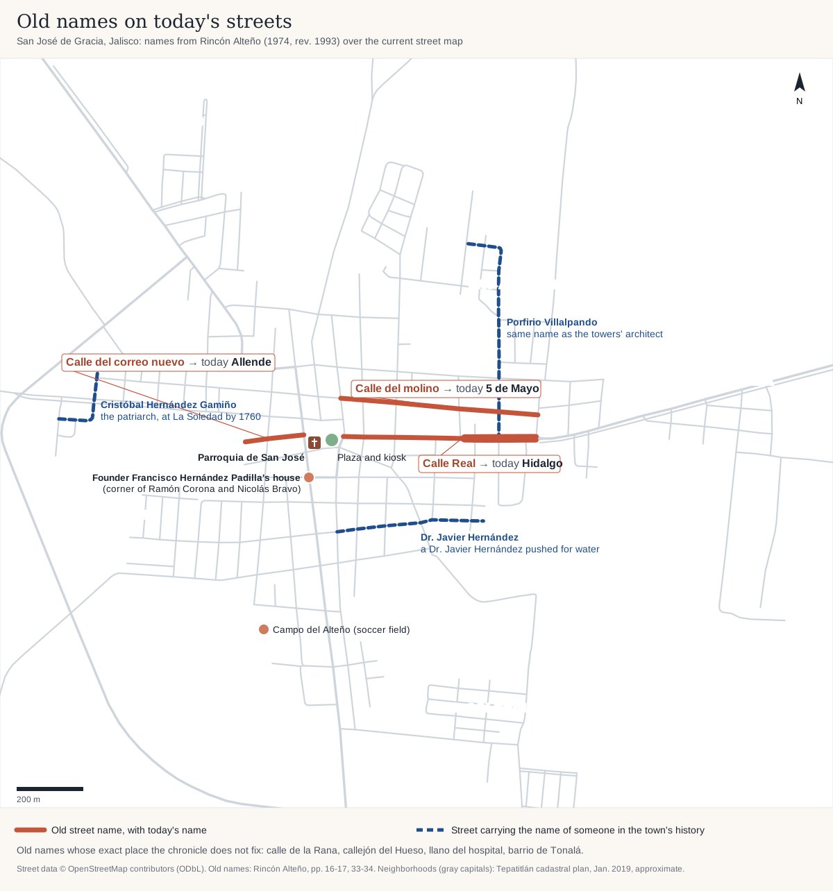
Calle Real is today's Hidalgo. Calle Allende was once the calle del correo nuevo, the new-post street, and the calle del molino is now 5 de Mayo. Older people called the block where Francisco Valle's family lived the llano del hospital, and the soccer field was there for a while. From the barrio del Colorín, people passed adobe and brick hand to hand to build the parish church. [per Rincón Alteño, pp. 16-17, 33, 40]
A very narrow lane was called the callejón del Hueso. The book does not say where the name came from, only that the lane led nowhere, except for courting couples looking for a quiet spot. [per Rincón Alteño, p. 17]
At the east end of calle Real began the old lane to San Antonio, Jaquetas and Arandas. It ran behind the house where the municipal delegate J. Trinidad Báez was killed on 19 September 1935, then on, full of fallen stones, to the old barrio de Tonalá, where Pedro Álvarez had a linseed mill. It crossed today's road to San Ignacio and joined the lane down to the Arroyo del Taray. [per Rincón Alteño, pp. 17, 34]
The Taray has a story, which the chronicler offers only as a possibility. The founder José Antonio built his house near the stream, and one day a small boy slipped on its rocks and cut his head. The master muttered "ah qué caray." Scolded by his mother, the boy promised to behave, because the patrón had said "ah que taray." [per Rincón Alteño, p. 28]
The Pozo Chino is a newer name. In 1945 or 1946 the parish priest Juan Hernández, Don Alberto Martínez, Don Santos Valle and Don Ramón Ruiz built the well with the whole town, on Sunday afternoons of volunteer work, the faenas. [per Rincón Alteño, p. 40]
Who lived and worked on the old streets
By the early 1900s the town had four linseed mills: Don Antonio Hernández's on 5 de Mayo, the last to close; Pedro Álvarez's in Tonalá; Don Valente Hernández's on Pedro Moreno; and Don Cristóbal Hernández's on the second block of calle Real. The oil went by mule to Mexico City, Guadalajara and Colima. There were tanneries on the last block of calle Aldama. [per Rincón Alteño, pp. 34-35]
Wheat grew in the middle of town. In 1932 it was still sown on a block of calle Real. [per Rincón Alteño, p. 17]
The tithe corn had its own warehouse. In June 1956 it was on calle Allende, half a block behind the church. On 30 June, Don Valeriano, father of the parish priest Juan Hernández, lit a cigarette while preparing to fumigate the corn, and the building exploded. He and two other men were pulled out burned. Don Valeriano died in Guadalajara in early July. [per Rincón Alteño, pp. 68-69]
The four founders' houses
By the chronicler's reckoning, each of the four Hernández Padilla brothers had his own house by about 1792 (their story is on the Hernández family page). Three still stood in 1993, marked with plaques. The fourth is gone. [per Rincón Alteño, pp. 12-13]
Francisco's house is where Ramón Corona turns into Nicolás Bravo, on the left coming from the parish; opening Nicolás Bravo cut off part of it. It passed to his son Próspero and down the family until the Aceves sisters bought it. After the last of them, Josefina Aceves González, died in 1990, her administrator and the parish priest Albino García H. gave it to the parish. The keys were handed over on 17 June 1993. [per Rincón Alteño, pp. 11-12, 26]
Antonio Rafael's house has a door frame carved JESUS MARIA Y JOSEPH 1792, with an iron cross set in the wood. It was known because the old way to the cemetery passed in front of it, a little past the last house of calle de la Rana. [per Rincón Alteño, p. 27]
José Antonio's house was by the Arroyo del Taray, out of town on the way to San Ignacio, later known as the casona of Don Emilio Ferreira. [per Rincón Alteño, p. 28]
Salvador's house was, in the chronicler's words, "the last to be built and the first to be gone." Around 1945 the chronicler saw only its foundations. A small brick monument marks the place, by the old lane to the cemetery that leaves through barrio de la Rana, and he complained that people had thrown stones at it. [per Rincón Alteño, pp. 13, 29]
José Hernández González told the chronicler that people told the branches apart by nickname: the Hernández Pata, the Hernández Hediondos and the Hernández Gamiños. The fourth nickname nobody remembered. [per Rincón Alteño, pp. 12-13]
The plaza: lost trees and a 200-year beam
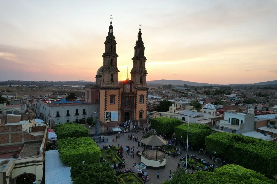
The plaza was once ringed with cedars and ash trees in round masonry planters where people sat. After the Cristiada they were cut down, perhaps, the chronicler suggests, to help forget the bitter moments tied to them (see The Cristero War). [per Rincón Alteño, p. 40]
Don Regino Rubio began the kiosk, and the municipal delegate Alberto Martínez fixed it up and roofed it. The wooden beam set in the kiosk to mark the town's 200 years was brought from the rancho of La Soledad, where the patriarch Cristóbal Hernández Gamiño had lived. [per Rincón Alteño, pp. 12, 38]
The old cemetery and the new
Until 1875 the dead of San José were carried to Tepatitlán for burial. That February the chaplain got permission for a campo santo on the field beside his house, a few steps from Francisco's. The first burial was on 14 February 1875: Guillermo Becerra García, six years old, of Las Hormigas. [per Rincón Alteño, p. 32]
In 1960 the new Junta de Mejoramiento Cívico, Moral y Material made the new cemetery its first project, on land given by Don Pedro Gutiérrez. In 1970 the old cemetery's entrance became an ossuary. [per Rincón Alteño, p. 72]
The barrios today
During the parish centennial in May 2010, the image of San José was carried each morning through the barrios, and each evening they walked in pilgrimage to the church: Panteón, La Plazuela, Veneritos, Pozo Chino, Estrella, Tepeyac, Ermita, Guadalupano, Arenal, Pueblito, Colorín and Potreritos. [per the 2010 fiesta program, Patronato de San José de Gracia, archived]
Colorín and Pozo Chino come straight from the chronicle, and Panteón and La Plazuela carry the names of the cemetery and the little plaza. Rana and Tonalá are not on the 2010 list. More on the fiesta is in the Fiesta Patronal.
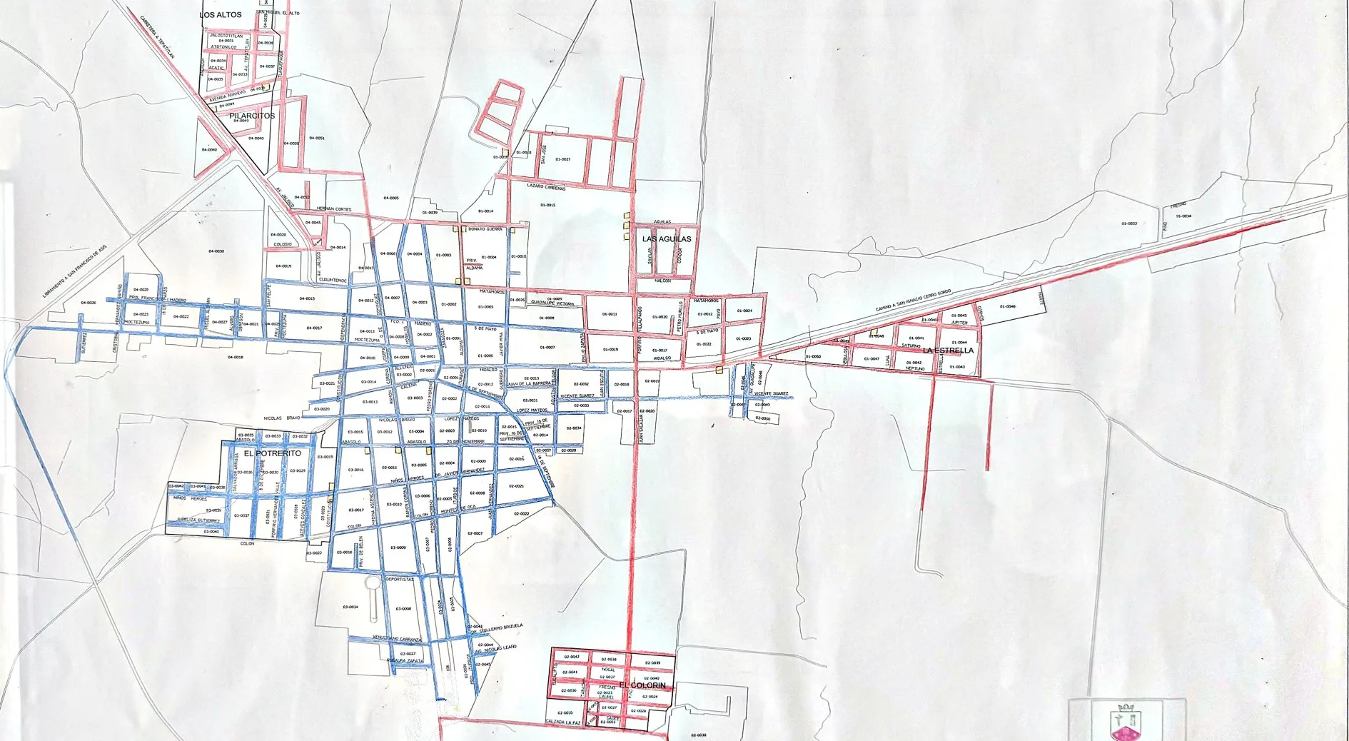
The town's cadastral plan, drawn by Tepatitlán's Jefatura de Catastro in January 2019, shows the colonias that grew after the chronicle: Los Altos and Pilarcitos on the road to Tepatitlán, Las Águilas and La Estrella to the east, El Potrerito to the west, and El Colorín to the south with the San José de Gracia subdivision beside it. [per the plano catastral, 2019]
Each new colonia gave its streets a theme. Las Águilas went with birds: Gavilán, Cóndor, Halcón and Pavo. La Estrella looked up: Saturno, Júpiter, Neptuno, Luna, Nebulosa and Cosmos. Los Altos named its streets after towns of the region, such as Jalostotitlán, Atotonilco, Acatic and San Miguel el Alto. El Colorín and the subdivision went with trees: Nogal, Fresno, Laurel, Sauce, Pino, Cedro, Roble and Olivo.
The plan puts colonia El Colorín along Calzada La Paz, south of the center. The chronicle never says exactly where the old barrio del Colorín was. It says only that its west-facing streets ended in stone fences and that brick for the temple was passed hand to hand from there. Today's colonia may cover part of the old barrio, or it may only share the name.
Walk it yourself
Most of this fits in a morning's walk: the plaza and its kiosk, Hidalgo (the old calle Real), the corner of Ramón Corona and Nicolás Bravo, then barrio La Rana for the 1792 door frame and Salvador's monument. The chronicler urged his readers to visit these places at least once. [per Rincón Alteño, p. 13] Our walking tour covers the center, and the old lanes start where it ends. If your family remembers another lost street name, send it to us.
Sources
- Taurino Arámbula Vázquez, Rincón Alteño (1974; text corrected June 1993): town limits before 1955, old street names, mills and trades, founders' houses, plaza, cemeteries (pp. 11-17, 26-29, 31-40, 68-69, 72) [local tradition]
- Patronato de San José de Gracia, Programa para la fiesta del Centenario de la Erección de la Parroquia de San José, 1910-2010 (sanjosedegracia.org, archived 6 Sep 2010): barrio processions, 8-14 May 2010 [primary]
- Gobierno Municipal de Tepatitlán, Dirección de Finanzas Municipales, Jefatura de Catastro: Plano catastral de San José de Gracia (January 2019), framed copy at the ASTEPA office; colonias and street names [primary]
- La Crónica de San José de Gracia [secondary]